Minnesota is one of the best walleye fisheries in North America, with more than 3,000 lakes supporting healthy populations. But not all walleye lakes are created equal. Some produce consistent 18-inch fish all summer; others are trophy factories that take patience. Knowing which lakes to target — and where to fish on them — is the difference between a cooler full of fillets and a long, quiet day on the water.
This guide breaks down the best walleye lakes in Minnesota using DNR electrofishing survey data, and explains how to use depth contour maps to find fish once you're on the water.
What the DNR Data Actually Tells You
The Minnesota DNR conducts electrofishing surveys on hundreds of lakes every few years. These surveys measure Catch Per Unit Effort (CPUE) — how many fish of a given species and size class are sampled per hour of electrofishing. High CPUE means a lake has a dense, accessible population.
When evaluating a walleye lake, look for:
- CPUE > 5 walleye per hour — indicates a solid population
- Average length > 16 inches — suggests good growth rates and older fish
- Consistent surveys over multiple years — confirms the population is stable, not just a temporary boom
- Population trend — a rising trend in recent surveys means the fishery is improving; a declining trend is worth noting before making a long drive
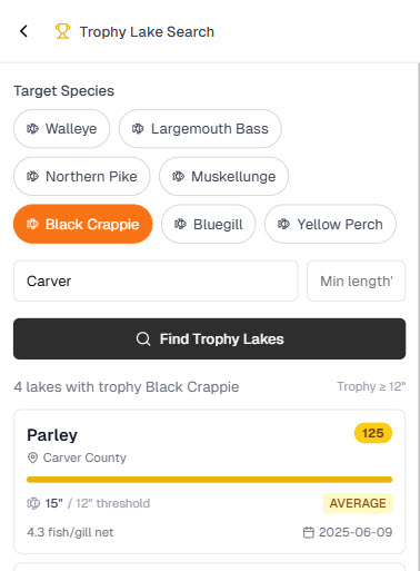
Fish Guide Pro's Trophy Lake Search puts this data at your fingertips, letting you filter Minnesota lakes by species and minimum fish size to find the right water for your goals.
Always check current regulations. Many of Minnesota's best walleye lakes have special slot limits, reduced bag limits, or size restrictions that change over time. A lake with trophy-size walleye in abundance may have a protected slot that requires releasing those fish immediately. The DNR publishes annual fishing regulation booklets, and Fish Guide Pro surfaces current regulation data for each lake so you know what you can keep before you leave the dock.
Top Walleye Lakes by Region
Northern Minnesota
Leech Lake (Cass County) is one of the most storied walleye fisheries in the state. At over 103,000 acres, it's Minnesota's third largest lake and consistently produces walleye in the 15-20 inch range, with legitimate trophy fish exceeding 28 inches taken every season. The lake plunges to 135 feet at its deepest, with a mean depth of 18.5 feet — extensive shallow structure makes it exceptional walleye habitat. Through summer, fish hold in 18-25 feet on the main basin, but the real action is on the points and saddles between the main lake and its many bays. Confirmed productive spots include GrandVu Flats (10-12 feet), the west side of Goose Island (8-12 feet), Bear Island's north end (8-12 feet), and Partridge Point. Look for sand-to-rock and sand-to-weed transitions as the primary structural key. Cisco (tullibee) are present as forage, which is a strong predictor of trophy-size walleye. Walleye regulation: possession limit 4, only one over 20 inches. Invasive species present: Eurasian watermilfoil, starry stonewort, and zebra mussel — clean your gear thoroughly.
Lake Winnibigoshish (Cass County) at 56,506 acres is a wind-swept, shallow lake (max depth 76 ft, mean 15 ft) that produces extraordinary numbers of walleye. For 2026, the picture here has an important nuance: the dominant 2019 year class has grown into the 18-to-23-inch protected slot, meaning those fish must be immediately released. Walleye under 18 inches and one fish over 23 inches may be kept. That makes Winnie an exceptional catch-photo-release destination for larger walleye, but harvestable "eater" sized fish (under 18 inches) are less abundant from the 2019 class than in previous years. The good news is a solid 2023 year class is developing — fish from that class were confirmed in DNR testing at 12-13 inches and should reach keeper size by 2027. For 2026, expect excellent CPR action on bigger walleye and target the sandy windward points and weed-flat transitions for keepers. Invasive species present: faucet snail, starry stonewort, and zebra mussel.
Mille Lacs Lake (Aitkin/Crow Wing/Mille Lacs County) was once the most famous walleye lake in the country and has been actively recovering under intensive DNR management. At 128,345 acres with a max depth of 40 feet, the lake's shallow, wind-swept basin is classic walleye habitat, and open-water walleye fishing is happening again with encouraging results. Fish the sand and gravel transition zones at 15-22 feet. Current walleye regulations (2026): 3-fish daily limit, all fish must be over 17 inches, and only one fish over 20 inches may be kept. There is also a night fishing closure from May 11 through August 31 — no fishing of any species from 10 p.m. to 6 a.m. Invasive species: Eurasian watermilfoil, spiny waterflea, and zebra mussel. Regulations here are among the most complex in Minnesota and have changed frequently — always verify current rules before your trip.
Lake Vermilion (St. Louis County, Tower area) is a northeastern Minnesota gem — at 39,302 acres with a max depth of 74 feet, it's a complex, island-dotted lake with incredible structural diversity. DNR surveys confirm excellent walleye abundance, with plenty of keepers in the 14-to-19-inch range, particularly in West Vermilion, and many larger fish as well. The lake carries a 20-to-26-inch protected slot with a four-fish bag limit — fish in that range must be released immediately, and one fish over 26 inches may be kept. Cisco are present as forage, a key ingredient for trophy walleye growth. The irregular shoreline, countless points, sunken islands, and rock piles create ideal walleye habitat throughout this lake. Spiny waterflea is the only invasive species confirmed — relatively clean for a northeastern MN lake of this size.
Lake of the Woods (Lake of the Woods County) belongs on any serious list of Minnesota walleye lakes. At 725,583 acres (including the Canadian portion), it is one of the largest freshwater lakes in North America. DNR fall surveys show walleye in the 11-to-25-inch range above the historic average, with the strong 2021 year class providing excellent harvestable-size fishing through 2026. Trophy fish up to 30 inches are sampled by DNR crews annually, and the abundance of walleye over 20 inches remains high. Walleye/sauger regulations: combined limit of 6 (no more than 4 walleye); all walleye 19.5–28 inches must be immediately released; one walleye over 28 inches may be kept. Northern pike also carry a slot: 30–40 inch pike must be released, limit of 3 with one over 40 inches allowed. The Canadian border waters add a unique dimension — sauger are often mixed in with walleye catches throughout the season. Invasives: spiny waterflea and zebra mussel.
Central Minnesota
Otter Tail Lake (Otter Tail County) is one of the clearest and deepest lakes in central Minnesota — 14,075 acres with a maximum depth of 111 feet and a mean depth of nearly 25 feet. That clarity and depth changes walleye behavior significantly. Fish run deeper during the day (25-35 feet in summer) and move shallower to feed at dawn and dusk. The clear water makes depth contour maps especially valuable here — you need to know exactly where the structure is before the fish go active. Cisco (tullibee) are present as forage, a strong predictor of quality walleye size. The lake also hosts lake sturgeon, making it a rare multi-species trophy fishery. No special walleye regulations beyond standard statewide limits. Zebra mussel is present.
Metro Minnesota
Lake Minnetonka (Hennepin County) often surprises anglers — at 14,216 acres with a maximum depth of 102 feet and a mean depth of 30 feet, it's a legitimately large and deep metro lake with solid walleye fishing. The connected basins create distinct habitat zones, and the evening walleye bite off rocky points can be outstanding from May through July. No special walleye regulations apply — standard statewide limits. The complex multi-basin structure rewards anglers who study the map before launching. Invasive species present: zebra mussel, flowering rush, and Eurasian watermilfoil.
How to Read a Depth Contour Map for Walleye
Walleye are structure-oriented fish. They use depth transitions, bottom composition changes, and physical features to ambush prey and regulate their temperature. A 1-foot depth contour map reveals all of these features in detail.
Key Features to Target
Points and Fingers
When a point of land extends into the lake, the underwater structure usually continues below the surface as a "finger" of shallower water. Walleye use these as highways, moving up at dawn and dusk to feed on shallower flats and sliding back to deeper water as the sun rises. Look for points where the depth changes from 8-12 feet to 18-25 feet within a short distance — the sharper the break, the better.
Saddles Between Islands
When two underwater humps or islands sit close together, the shallow zone between them creates a natural fish funnel. Baitfish school over these saddles, and walleye cruise below, picking off stragglers. These spots often don't look like much from the surface but show up clearly on a contour map.
Inside Turns
Where the depth contour lines curve back toward shore, they form an inside turn — a sheltered bay on the structure. Walleye love inside turns because wind and current push baitfish into the corner, and the fish can feed with the sun at their backs. Look for inside turns in the 15-22 foot depth range on walleye lakes.
Sunken Islands (Humps)
Isolated humps that top out at 12-18 feet with deep water on all sides are among the most productive walleye spots on any lake. The depth on top is within walleye's preferred feeding range, and fish can approach from any direction. On lakes with heavy fishing pressure, humps that top out slightly deeper (14-18 feet) are often overlooked and hold larger, less-pressured fish.
Reading Contour Line Spacing
The spacing between contour lines tells you how steep the bottom structure is:
- Tightly-spaced lines — steep drop, fish often suspend just off the break
- Widely-spaced lines — gradual slope or flat, good for trolling or drifting
- Lines that suddenly spread out — transition from hard to soft bottom, often a prime walleye zone
On a 1-foot interval contour map like Fish Guide Pro provides, you can see every subtle transition that a 5-foot or 10-foot map would miss entirely.
Seasonal Walleye Patterns and Structure
Spring (May–June)
Walleye are in aggressive post-spawn mode and push shallow — often 4-10 feet. Target rocky and gravelly areas near the spawning flats, and look for the first major depth break off those areas. Fish are hungry and moving; the bite can be excellent.
Summer (July–August)
Fish go deeper to find cooler, oxygenated water. The thermocline typically sets up at 15-22 feet, and walleye stack on structure at that depth. Mid-lake humps, deep main-lake points, and the edge of weed lines at 12-18 feet are all prime. Dawn and dusk bring fish shallower; midday, go deeper.
Fall (September–October)
Fall is the best time to catch big walleye. Fish fatten up for winter and feed aggressively. They move back shallow — 8-15 feet — and follow baitfish schools over main-lake flats and onto the upper faces of points and humps. The evening bite can be electric in October.
Spring Walleye Tactics from Minnesota Guides
The seasonal overview above tells you where walleye are in spring. What follows is the tactical detail — the kind of thing you pick up after seasons on Minnesota's best walleye lakes.
Follow Water Temperature, Not the Calendar
Water temperature is a more reliable trigger than dates. Two thresholds matter most for spring walleye:
Low 40s°F — post-spawn cold water. Walleye have just finished spawning and hold in surprisingly shallow water, 1 to 7 feet, often right against the bank or over gravel flats. The best bites happen in the evening, overnight, and early morning. Fish are lethargic; slow your presentation and stay patient.
55°F — the golden zone. This is when everything changes. Perch spawns wrap up at 45–53°F in 4–10 feet of weeds, and shiner spawns peak on shallow sand flats at 55–60°F. Walleye key in on both. When surface temps hit 55°F, baitfish are concentrated and walleye are actively feeding — this is the window for consistent spring action on top walleye lakes.
57°F and warmer: Leeches start outperforming minnows as water temperatures climb. If you're still fishing jig-and-minnow into late May and wondering why the bite has slowed, switch to a leech on the same jig.
Jig and Minnow is the Starting Point
A jig tipped with a minnow is the dominant spring presentation on Minnesota walleye lakes. Spottail shiners are the preferred minnow on lakes like Leech Lake — match the size of the baitfish that are naturally present. Fathead minnows work when shiners aren't available.
Jig weight: Go as light as you can manage given depth and wind. Walleye hold in 4–15 feet in spring, so 1/16 to 1/8 oz is typically right. Tungsten jigs are worth the extra cost — heavier for their size means better sensitivity and a smaller profile at the same weight.
Line setup: 8–10 lb braid mainline with a 6–8 lb fluorocarbon leader. The braid gives you sensitivity and casting distance; the fluorocarbon leader is nearly invisible in clear spring water. In clear water, walleye spook early — guide reports from Brainerd-area lakes note fish bolting at 40 feet. Cast long, work the jig back slowly, and keep the boat off the structure.
Color selection: Guides use a simple framework — chrome or silver in bright sun with clear water and wind; translucent colors (chartreuse, pink, clear glitter) in bright, calm, clear conditions; matte earth tones (olive, brown, black) in cloudy water, stained conditions, or under heavy pressure.
Read the Bite: Up or Down
One of the most useful spring skills is detecting whether walleye want the bait moving up or staying on the bottom. This can vary day to day — sometimes hour to hour.
Down-bite: Drag the jig along the bottom with a 5–10 second pause. Let it sit. Fish are reluctant to rise and will pick it off the substrate. Light taps or slack line often signal a down-bite.
Up-bite: Fish will rise 4–5 feet off the bottom to hit a moving jig. Short hops — 6 inches to a foot — with the jig returning to the bottom between lifts. On up-bite days, a more active retrieve triggers better strikes.
When you arrive at a new spot, alternate between both presentations for the first few drifts before deciding which the fish prefer that day.
Wind is Your Friend
Wind-blown points are one of the most consistent walleye producers in spring. When wind blows into a point or shallow flat, it concentrates baitfish on the windward side and puts walleye on the feed. Guides on Leech Lake, Winnie, and Mille Lacs consistently report that wind events correlate directly with improved bite windows — "when the wind kicks up, everybody catches fish."
Don't anchor on the calm side of a lake in a breeze. Motor to the windward shore and work the exposed points. The extra effort is almost always rewarded.
Structure Transitions to Prioritize in Spring
From guide reports on Leech Lake, Winnibigoshish, and Mille Lacs, the highest-percentage spring spots share common features:
- Sand-to-rock transitions at 6–15 feet, especially near spawning gravel
- Sand-to-weed transitions as emerging cabbage and milfoil begin growing in late May and early June — walleye use the weed edge as a current edge and ambush point
- Inside turns at 8–15 feet where wind and current funnel baitfish into a corner
- River and creek inflows — current entering a lake concentrates baitfish early in the season before the main basin warms
- Shallow flats with deep water adjacent — the nearby depth lets fish retreat quickly when light or pressure changes
On clear lakes like Otter Tail and Vermilion, give these transitions extra room. An inside turn at 10 feet fishes best from a long cast; crowding the structure pushes fish into deeper water.
Using Fish Guide Pro for Walleye
Fish Guide Pro's AI Hotspot Finder analyzes lake structure, DNR survey data, and species behavior patterns to rank the top fishing zones on any Minnesota lake. For walleye, it identifies the points, saddles, and depth transitions most likely to hold fish by season and time of day.
The DNR Survey Visualizer shows CPUE, average size, population trend (up, down, or stable), and percentile rank compared to every other surveyed lake in Minnesota — so you're not just reading that a lake is "good for walleye," you're seeing exactly how it stacks up. It also flags cisco forage presence, which is one of the strongest predictors of large walleye in a lake.
The Lake Information feature surfaces current special regulations including protected slots and bag limits — the kind of detail that's easy to miss in a 100-page DNR regulation booklet but critical to know before you go.
Combined with 1-foot depth contours, you can research a new lake in 15 minutes and arrive with a real plan — not just a hope.
The Trophy Lake Search lets you filter for lakes meeting specific walleye size and CPUE criteria, so you can match your goals (harvest-focused, CPR trophy fishing, or somewhere in between) to the right water before you ever load the boat.