A depth contour map is the closest thing fishing has to a cheat code. Where most anglers pick spots based on experience or guesswork, anglers who can read a lake map are looking at a complete picture of the underwater world — every drop, ledge, flat, hump, and channel — before they ever wet a line.
This guide explains exactly how to read a lake depth contour map, what features to look for by species and season, and why contour resolution matters more than most anglers realize.
What is a Depth Contour Map?
A depth contour map (also called a bathymetric map) shows the shape of a lake's bottom using lines that connect points of equal depth — similar to how a topographic map shows elevation on land.
Each line on the map represents a specific depth. Where lines are close together, the bottom drops steeply. Where they're spread apart, the bottom is gradual. The pattern of lines tells you everything about the lake's underwater structure.
How Contour Intervals Work
The "contour interval" is the depth difference between adjacent lines. Common intervals are 1 foot, 5 feet, and 10 feet.
A 10-foot interval map might show the lake going from 10 feet to 20 feet with a single line between them. In reality, there could be a critical 14-foot flat holding walleye — you'd never know it exists.
A 1-foot interval map shows every subtle feature: the gradual taper of a sandbar, the sharp edge of a submerged rock pile, the slight rise of a mid-lake hump. These are the spots that hold fish, and they're invisible on lower-resolution maps.
The Five Structures Every Angler Should Know
1. Points
A point is where the shoreline juts out into the lake. Underwater, the structure usually extends beyond the visible land, creating a gradually tapering underwater shelf.
Why fish love them: Points concentrate baitfish, create current breaks on windy days, and give predators a naturally occurring ambush position. Fish move up and down points throughout the day, following the depth where they're most comfortable.
How to read them on a map: Look for contour lines that spread out and then close back in as the point tapers into deeper water. The tip of the point — where the contour lines pinch together — is often the most productive zone.
Best species: Walleye, bass, northern pike
2. Inside Turns (Pockets)
Where the contour lines curve back toward shore, they create an inside turn or pocket. This is essentially the opposite of a point — a sheltered indentation in the structure rather than a protrusion.
Why fish love them: Wind pushes baitfish into inside turns, trapping them against the curved structure. Predators position below the baitfish and wait. On windy days, the inside turn on the windward shore of a lake is often the best spot on the water.
How to read them on a map: Inside turns are the curves in contour lines that point toward shore (or toward the center of the lake, if you're looking at a hump). They're easy to miss on a cluttered map but jump out once you know what to look for.
Best species: Walleye, largemouth bass, crappie
3. Humps (Sunken Islands)
A hump is a rise in the lake bottom that doesn't reach the surface — an underwater island. On a contour map, humps appear as a set of concentric rings, like a bullseye, surrounded by deeper water.
Why fish love them: Humps are isolated pieces of structure in open water. They concentrate baitfish from all directions, and predators stack around and on top of them. The transition from the top of the hump to the drop-off on the sides is often the most productive zone.
How to read them on a map: Look for a series of concentric closed contour lines that don't connect to the shoreline. The depth at which the hump tops out matters — walleye generally prefer 12-20 feet, bass often shallower, lake trout deeper.
Best species: Walleye, smallmouth bass, lake trout, cisco
4. Saddles
A saddle is the connecting zone between two humps or an island and a nearby hump. On a map, it looks like an hourglass — two sets of concentric rings connected by a narrower band of slightly shallower water.
Why fish love them: Baitfish move across saddles when traveling between areas of cover, and predators set up in the saddle to ambush them. In lakes with current or strong wind, the funnel effect makes saddles extremely productive.
How to read them on a map: Look for two hump formations connected by a shallow neck. The shallowest point of the saddle is where you want to start fishing.
Best species: Walleye, northern pike, muskie
5. Flats
A flat is an area where the bottom is relatively level — the contour lines are spread far apart or absent entirely. On many lakes, the main flats are at 5-12 feet, with deeper flats at 15-22 feet.
Why fish love them: Flats support weed growth (in clearer lakes), hold invertebrates, and give fish a large area to spread out and feed. In summer, walleye often cruise main-lake flats at night. Panfish school on shallow flats through much of the season.
How to read them on a map: Look for wide spacing between contour lines, especially where the spacing is consistent over a large area. Note the depth — a 15-foot flat holds different fish than a 6-foot flat.
Best species: Perch, crappie, bluegill, walleye (at night), northern pike (in weeds)
Reading Contour Line Spacing
The spacing between contour lines is one of the most important things to learn. Here's a quick reference:
| Line Spacing | What It Means | Fishing Strategy |
|---|---|---|
| Very tight | Steep cliff or rock face | Fish just off the break, let lure fall |
| Tight | Sharp drop-off | Work the break, suspended fish likely |
| Moderate | Gradual slope | Classic walleye structure, troll parallel to break |
| Wide | Gradual taper or flat | Drift presentations, covers more water |
| Very wide | Flat bottom | Slow presentations, look for weeds or other cover |
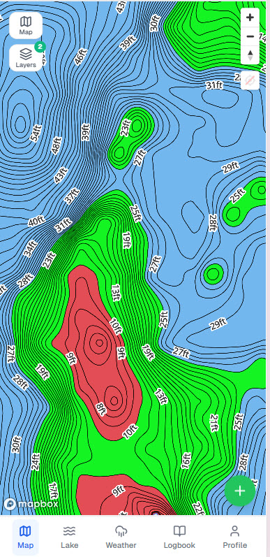
Depth Shading: Seeing Structure at a Glance
Contour lines give you precise depth information, but depth shading adds a layer of visual clarity that makes structure immediately obvious. Fish Guide Pro's depth shading overlays a color gradient on the contour map, with shallow water appearing as warm colors and deep water as cool colors.
With depth shading, you can instantly see:
- Where the deep water is relative to the rest of the lake
- How sharp or gradual the drops are
- Where isolated humps are located in the main basin
- The overall shape and character of the lake
This is especially useful when exploring a new lake — you can get oriented in seconds and start identifying promising areas before zooming in to read the contour lines in detail.
Why 1-Foot Contours Change Everything
On a standard 5-foot interval map, a walleye lake might look like a simple bowl with a flat bottom at 25 feet. On a 1-foot interval map of the same lake, you'd see:
- A gradual gravel-to-mud transition zone at 17-19 feet that holds fish all summer
- A series of subtle humps on the main-lake flat that top out at 21-22 feet
- The exact depth where the weed edge terminates (say, 13.5 feet), not just "somewhere between 10 and 15 feet"
- Subtle points that jut out 40 feet from a shoreline break
These features don't show up on coarser maps. But they're where the fish are.
Minnesota's DNR has conducted detailed lake surveys producing high-resolution bathymetric data for hundreds of lakes. Fish Guide Pro processes this raw DNR raster data into 1-foot contours, giving anglers access to the full resolution of the original surveys.
Putting It Together: Pre-Trip Map Research
Here's the workflow for researching a new lake before a trip:
-
Open the lake in Fish Guide Pro and enable depth shading. Spend 60 seconds getting a feel for the lake's overall shape — where's the deep basin, where are the shallow bays, is the structure complex or simple?
-
Identify the main structural features — find the major points, obvious humps, and any islands with saddles connecting them.
-
Filter by depth zone for your target species. For walleye in summer, focus on 15-25 foot structure. For bass, look at 8-15 feet. For crappie, check the deep edge of the weed line.
-
Use the AI Hotspot Finder to see the top-ranked spots for your target species and the current season. Compare these to your own map reading — the AI often highlights spots you'd have noticed anyway, and occasionally surfaces one you'd have missed.
-
Mark 6-8 waypoints at spots you want to investigate. Plan a route that lets you fish them efficiently without a lot of running.
-
Check the DNR survey data for the lake. What species are abundant? Are walleye in the 15-18 inch range, or are you looking at a lake with good numbers but small fish? This sets expectations and can confirm or change which species to target.
Fifteen minutes of map research before a trip is worth more than an hour of searching on the water.
Common Mistakes Anglers Make Reading Contour Maps
Focusing only on the deepest water. Deep water is safe for fish but rarely where the most active feeding happens. Fish near the deepest structure in the lake, not in it.
Ignoring shallow water. First-light and last-light trips to 4-8 foot flats adjacent to deep structure can be extremely productive, especially in spring and fall.
Overlooking subtle features. On a 5-foot interval map, a 2-foot hump doesn't exist. On a 1-foot map, you can see it clearly — and it's often exactly the type of subtle feature that holds fish when nothing else is working.
Not accounting for seasonal position. A walleye point that's on fire in May might be empty in August. Fish move with temperature, oxygen levels, and forage. Great structure at the right depth for the season is the target.
Ignoring map scale. A point that looks big on a zoomed-out map might be tiny when you arrive. Always zoom in to understand the actual dimensions of a structure before committing to it.
Reading a depth contour map is a skill that pays dividends on every body of water you fish. The more time you spend studying maps — and then going fishing and verifying what you see — the faster you'll become at identifying productive water on any lake.