Not every trip needs a boat, a trailer, and a full Saturday. Sometimes you've got an hour after work, a rod in the trunk, and one question: where's the closest place I can fish from shore? Shore Fishing Near Me in Fish Guide Pro lists the public fishing piers and shore sites closest to you and shows what lives in each lake, so that hour goes to fishing instead of driving around looking for somewhere to cast.
I built this one because I needed it. I don't always get a chance to take the boat out, but my kids love fishing, so finding a fishing pier or a spot on shore matters to us. I wanted a quick way to find places to go, and new ones too, so we're not always heading to the same lake or the same stretch of river bank. Now it's the first thing I check when we've only got an hour.
What It Does
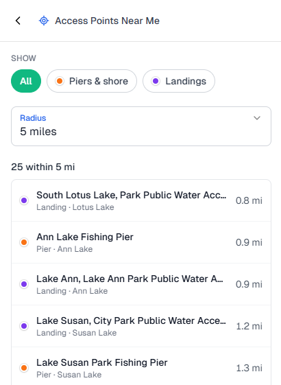
Open Access Near Me in Fish Guide Pro and tap Piers & shore. The screen switches to Shore Fishing Near Me and lists only public fishing piers and shore sites, nearest first.
Every row tells you what kind of spot it is (Pier, Shore site, or Landing) and which lake it's on, so you know what you're getting before you tap. When two spots share a name, the row adds the park or the side of the lake, like "Minnewashta Fishing Pier · north site," so you head to the right one.
You can also turn on the Piers & shore and Landings layers on the map to see the public access around a lake at a glance.
Open Shore Fishing Near Me →
See What's in the Lake Before You Go
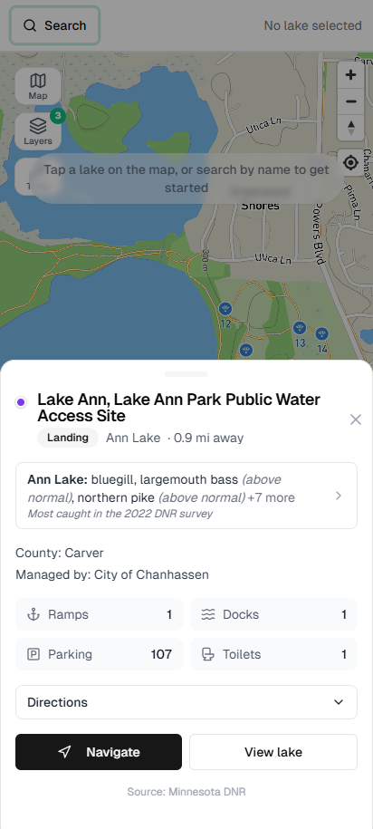
Every pier and shore card shows what the most recent full Minnesota DNR survey found in that lake. For example:
Ann Lake: bluegill, largemouth bass, northern pike +7 more
Most caught in the 2022 DNR survey
- It lists the fish people actually go after, not suckers or minnows, and tells you how many other species turned up.
- If the DNR rated a species above normal for that type of lake, the card says so. It never guesses.
- Surveys more than 10 years old are marked (older survey). Lakes without a survey say No DNR fish survey on file.
- Tap the line to open the full lake report, with the same survey broken down by species, numbers, and sizes.
From a pier you're usually after panfish and bass, so knowing what the DNR actually found helps when you're choosing between two piers ten minutes apart.
Lake names follow the DNR's records, so you'll see "Ann Lake" rather than "Lake Ann."
Minnesota's Public Fishing Piers and Shore Sites, From DNR Data
Every spot comes from the Minnesota DNR's statewide inventory of public fishing sites: fishing piers, shore fishing areas, and boat landings. Fish Guide Pro puts them on one map with each lake's survey right beside them, so you don't have to look lakes up one at a time on the DNR website.
The map is only as complete as the DNR's list. If you know a public pier or shore spot that's missing, let us know and we'll check it out. (Fish Guide Pro isn't affiliated with the Minnesota DNR.)
Help Decide What Comes Next
Pier and shore cards include a short line: Shoreline and weed info for this spot: not available yet. Want it? Tap Vote and it's counted, one vote per spot. The spots anglers vote for most are the ones that get shoreline, weed, and access details first.
Best used for
- ✓ Finding a public fishing pier near you for an hour after work
- ✓ Taking the kids fishing without a boat
- ✓ Checking whether the park down the road has a pier worth walking out on
- ✓ Seeing which nearby lake holds bluegill, crappie, or bass before you pick a pier
- ✓ Getting a feel for the shore access on a lake you've never fished
- ✓ Having a backup spot close by when the first pier is crowded
Frequently Asked Questions
Is Shore Fishing Near Me free?
Yes. Piers & shore and Landings are part of the free tier. Create a free account to use them, and try the full version free for 7 days.
Where can I fish from shore in the Twin Cities?
Open Shore Fishing Near Me anywhere in the metro and the closest public piers and shore sites are listed first, each with its lake and what the DNR found there.
Where does the pier and shore data come from?
From the Minnesota DNR's statewide inventory of public fishing sites, which covers fishing piers, shore fishing areas, and boat landings. Fish survey information comes from DNR lake surveys. Fish Guide Pro isn't affiliated with the DNR.
Does it cover all of Minnesota?
It includes every public pier and shore site in the DNR's statewide inventory, from the metro to up north. If you know of one that's missing, let us know.
Does it show weeds, parking, or shoreline conditions?
Not yet. Each pier and shore card has a Vote button so you can tell us which spots you want that info for first.
Why does a lake show an older survey year?
The card uses the most recent full DNR survey. A smaller follow-up survey may be newer but doesn't sample the whole fish community. Surveys more than 10 years old are marked (older survey).
Do I need a fishing license to fish from shore or a pier?
Yes. Shore and pier anglers need the same Minnesota fishing license as boat anglers. Anglers under 16 don't need one. Check the Minnesota DNR for current rules.
Found a pier worth trying? Open the lake's full DNR Survey Data, check its Contour Map for the drop-off you can reach with a cast, or use Lake Finder to search more lakes by species or county. Want bass ideas? See our guide to bass fishing near you.